Passages to New Caledonia
Sailing or motoring to New Caledonia is an enjoyable experience so long as you pick the correct weather window and the vessel is seaworthy.
Picking the weather is easier than ever these days with long range weather forecasts and satellite imagery. But there is a knack to doing it.
My wife, Frederique and I have made these passages over the past 30 years we have been annually migrating between the Pacific Islands, Australia and New Zealand aboard the Moira.
90% of our passages have been relaxing, and pleasant. The methods we use are described in full detail on the cruising guide to Vanuatu and on the cruising guide to New Caledonia. On the guides you will find complete details on ocean passages, where to leave from and when to go.
If you want to stop at the Chesterfields or the Entrecasteaux reefs.
If you want to make "magic" passages get our cruising guides and learn how to do it yourself..
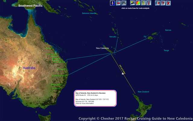
Navigation chart for passages from the Rocket Cruising Guide to New Caledonia.
On the Cruisng Guide, if you point to a route you'll see a summary of port to port distance in nautical miles, the probable number of days sailing and the GPS coordinates of arrival and departure ports.
Click on the route and you'll go to a page describing the best time of year to go and the weather conditions to look for before heading out. There are aerial photographs, approach routes, photo descriptions, email addresses, phone numbers and VHF contacts of the marinas in Australia and New Zealand that we recommend you use for arrival and departure. We have included GPS routes that go from the departing marina to the arriving marina. Load the route into your plotter and you can sail from one port to the other without a problem - we have sailed these routes many times ourselves, often turning on the autopilot when we clear port and turning it off when we arrive at our destination.