
"Wow its amazing!
Well done to you, its nice to see some one doing something properly!"
Bevan Carr
The Rocket Cruising Guide to New Caledonia
versus the 1996 printed book
| Feature | Rocket Guide | Printed Book |
|---|---|---|
| Latest revision (actual changes to anchorages, services, formalities, images, dive spots, stores, facilities, etc ) | 2024 | 1996 |
| Number of Anchorages presented | 220 | 138 |
| Number of route maps between anchorages | 60 | 0 |
| Number of tried and proven GPS routes | 240 | 0 |
| Index for instant look up of an anchorage or route map | Yes | No |
| Vertical survey quality, high resolution aerial and Satellite Images of anchorages in full color | 212 | 0 |
| Total number of photos | 1020 including virtual reality and 360° photos | 54 (mostly Black and white) |
| Go from any anchorage or chart view to any other with two clicks | Yes | No |
| GPS locations are WGS84 compliant | Yes | No |
| High resolution photos of the anchorages from ground level | Yes | No |
| High resolution approach photos of anchorages | Yes | No |
| Tidal Information - offsets of tides from Noumea tides. | Yes | No tide information |
Charts + Guide = Security + Confidence
The basic idea of a chart or a cruising guide is to help you know as much as possible about an anchorage and the passages to it before you actually head off to go there with your boat and loved ones. It's a question of security as well as pleasure and confidence when going somewhere you've never been before.
Let's take an actual example from an anchorage in the Isle of Pines - a group of islands south of Grande Terre and a favorite cruising area for visiting yachts. I've selected Ilot Brosse, also known as Ilot Alcmene for the comparison.
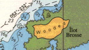
Here is what you see for Ilot Brosse on the official hydrographic map:
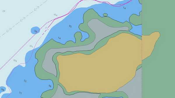
Here is what you see for Ilot Brosse on the vector electronic charts::
And here is what you see in the Cruising Guide to New Caledonia book:
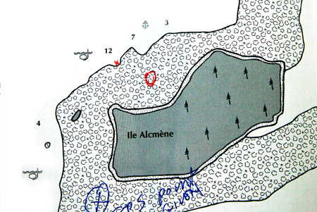
On the lower left corner of the mud map drawing from the book I have drawn in an X - this is where the book says the anchorage is located according to their GPS position. The location the book gives is actually on top of a very shallow coral reef and your yacht would be aground long before you reached this position.
The real anchorage is roughly where I have drawn a red circle and the entrance to the anchorage is where I have put a small red x. Now let's compare this mud map to what we have on the Nautical Guide to New Caledonia.
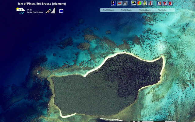
Here is what you see on our new Nautical Guide to New Caledonia.
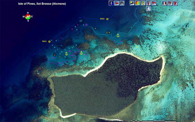
This is a survey quality aerial photograph of the island. The above image is nowhere near the quality of the image you will see on the program. The image presented on this web page is only 700 pixels wide - the one on the program is 2048 pixels wide and you can see every coral head with amazing clarity. Compare this image with the ones above and you will immediately appreciate the advantages of seeing reality over a sketch.
You get a lot more information than that on the program. If you put your cursor over the little sailboat icon you get directions on approach to the island like this:
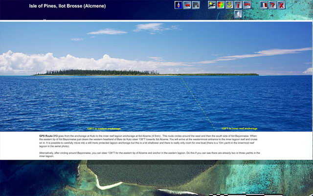
You have a GPS route number - and all of the routes are stored as .gpx files in a folder called ROUTES . The gpx files can be imported into most plotters and GPS trackers. These GPS routes are spot on, verified many times by myself and other yachts who use our guide.
The book has no routes at all, no suggestions on how to get from one anchorage to another.
Our sailing directions give you exact instructions for sailing to Ilot Brosse from Kuto anchorage in Isle of Pines.
Now that you know how to get there and how to enter the anchorage lagoons, put your cursor over the yellow anchor on the right to find out about the eastern most anchorage.
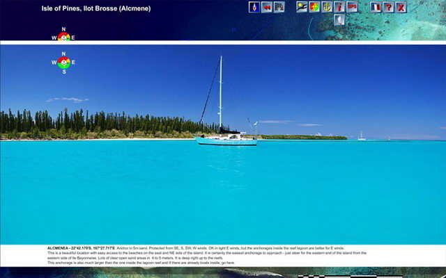
An image of that anchorage pops up instantly along with a GPS position accurate to within 5 meters, the type of bottom and related anchoring conditions, depth of the anchorage, protection from various winds, etc.
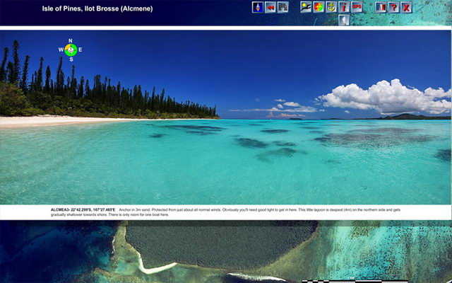
There are three anchorages offered for this island and this is the middle one - very protected and beautiful:
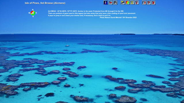
And this is the third anchorage, the most westerly one with GPS points, depths and anchoring conditions.
Is that it? No way. Click on the i icon and this is what you see:
Now you know that if you want to listen to the weather forecast on VHF Channel 66 at 48minutes after the hour, that the mobile phone works well here so you can access the Internet and that there is TV (also you can see the evening weather broadcast).
Notice the menu bar with information on the beaches and the reefs. Put your cursor over the NW beach and you see this photo:
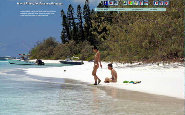
Here we have information about the tours from the local hotels to this island and their picnic facilities.
Now have a point to the menu item NE beach - Wow, makes you dream about going there, right?
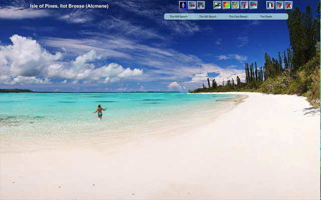
There's more photos of the beaches and the reefs at Ilot Brosse but you get the idea.
Our guide has this level of information instantly available for 220 anchorages all around New Caledonia, from the reefs to the north of New Caledonia to Isle of Pines and the Loyalty Islands.
Of course, you have to get to the anchorage in the first place.
In the book you have no anchorage index so it is a page flip job to try and find first the section on the Isle of Pines and then the anchorage itself.
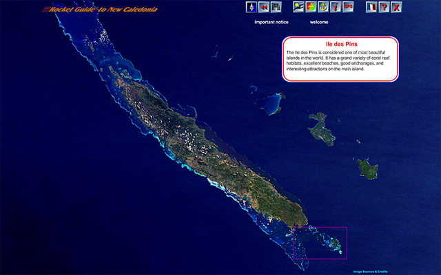
On our guide you start with a satellite image of all of New Caledonia (actually you can be anywhere in New Caledonia on the guide and get to any anchorage anywhere in two clicks).
You point to the various areas of the islands to find out what's where. If you point to the Isle of Pines you see this:
Click on the Isle of Pines and you zoom in to see this:
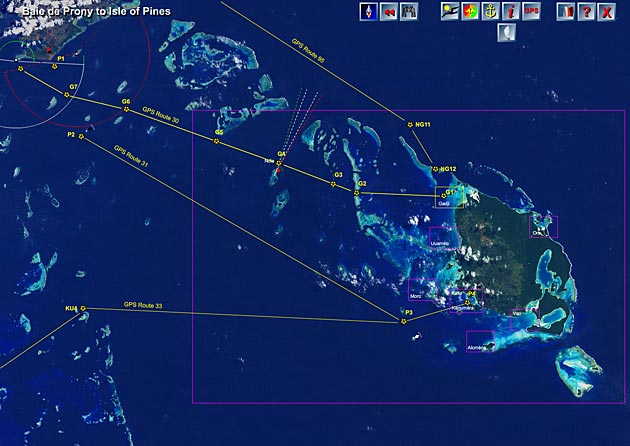
This level gives the various routes to go to and from the Isle of Pines, you'll get exact distances and GPS points for each route so you can plan your cruise there and back.
There is also important information on wind directions and currents.
If you wanted now to look at the next satellite image to the west or north just click on the edge of the image and you'll jump to the next photo-chart in that direction.
But for now, we'll click on the Isle of Pines to zoom in even closer for a detailed look at routes in and around Isle of Pines.
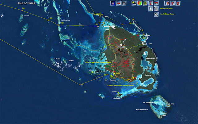
From here you can zoom in again to the image I showed you above on how to get to Ilot Brosse or you can click on the yellow anchorage at Ilot Brosse or any of the other anchorages on Isle of Pines to instantly zoom in and see them in full detail.
Ease of Access to highly accurate cruising and anchoring information
This gives you an idea of what's on the guide that you will not find in the outdated book or anywhere else and the ease of accessing that information.
The book has no information at all about how to get your boat from one anchorage to another, no suggested routes, and no easy way to find an anchorage you are interested in.
In addition to the very user-friendly way of simply clicking on the photo-chart to zoom into an anchorage, you could also have clicked on the binocular icon to see a quick listing of every anchorage and route map in New Caledonia. So if someone says you should check out Ilot Brosse you would Just click on the binoculars, then on the name Brosse and pop - you are there seeing it from a bird's eye view in living color.
And that's just ONE example of 220 anchorages on the Guide, many of the others have lots more photos and detailed information including virtual reality sphere images of New Caledonia's Lagoon like these.
Want to see the guide in action? Here are some video tutorials on the Rocket Guide.
Charts + Guides = Cruising Joy
 If you want the best information for ther security and safety of your friends and family when exporing the New Caledonia lagoons and islands order the Rocket Cruising Guide to New Caledonia right now and start planning your adventures.